Sunday 31 March 2019

Daffodil Dawdle

This was a new walking adventure for me... joining a Long Distance Walkers Association event, the Daffodil Dawdle. It was a bit of an early start as the clocks had just gone forward, to meet Jane, my fellow Bury St. Edmunds Rambler and Joyce's Weekly Walks walker, and drive to the start in Stradbroke for registration at 7:30 a.m. and an 8 a.m. start.

Jane and I were doing the short distance of 18 miles, although there was an option to do a full 26.1 mile distance. This was our route.


Not many photos as we weren't really dawdling, with all of miles 2 to 6 at an average of less than 17 minutes a mile, and the rest not much slower. I was glad of the stop at the checkpoints in Weybread and then Hoxne (with some sandwiches) and the yummy soup at the end.

We registered in the village hall.


There was quite a crowd of us ready for the 8:00 start.


 Off we went through Stradbroke.


This cherry blossom was very fulsome, even though it had lost a lot of petals.


At the first checkpoint we were checked in by Chelle sounding out our numbers to be ticked off in best bingo-caller style. I'll be seeing her again in Mallorca later this week.


 The daffodil sign highlighted the gate we had to climb over.


We joined the Angles Way for part of our route, which was very pleasant.


We passed  Brockdish Church. It may have been a 'dawdle', but visiting churches along the way wasn't on the agenda.


Eventually we came to cross the Waveney and meet the start of the Mid-Suffolk footpath I had walked over a couple walks recently (Part1 and Part2). And today I got to walk the bit we had missed by starting at Hoxne village hall.


 I do love walking beside a river.


 We entered Hoxne

...and reached out 13 miles checkpoint at the village hall. This time I didn't forget to look for the stone with the inscription about King Edmund.


Here we paused for about 20 minutes for some welcome refreshments and a bite to eat.


Now we had (nominally) only 5 miles left to go. We had managed the first 13 miles in just under 4 hours, so had plenty of time to get back. We had lost the 26 milers now, who were on a different route, and we were rather spread out. No more just following those in front, I used the map I had made from the GPX file we were sent a link to and Jane kept track of where we were and what turns we had to make for the excellent set of instructions we were provided with. So we had a bit more time to enjoy the flowers.


We nearly went wrong just before Thorpe Hall - we could see a couple in front of us who had stayed on the track rather than going straight on where it turned left. Fortunately Jane realised and we got to see Thorpe Hall


On the home stretch now, we walked along a drive lined by daffodils.

 ..and into Stradbroke


and back to the Community Centre.


Just before we got there we met Chris Flood, looking for her husband arriving and got photographed for the Bury St. Edmunds Ramblers facebook group. We checked in and had some welcome soup, bread and tea before collecting our certificates.


And here is mine. I hadn't realised we were being timed!


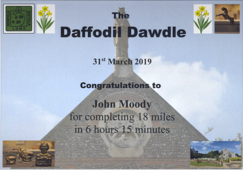
Well the route was actually 18.75 miles and, with our little detours, we actually did nearly 19, and we did stop twice so were walking for less than 6 hours. Not as fast as most, but I thought we did pretty well.

You can find more details of our route on my MapMyWalk log here.

Thanks to all the organisers, caterers and marshals for making it work and be such a fun event, and Jane for keeping me company (and on track) all the way round. Will I do another one? Well I was glad I only did the 18 miles, even though I felt I could keep going at the end, and the pace was just a bit quick for me at times. But it was good fun and a beautiful walk. We'll see.

Friday 29 March 2019

East Bergholt Walk


"The weather forecast is for mild, dry conditions this week so let's go and explore Flatford and the delights of Constable Country this Friday (March 29th). We will car share from Skyliner Way Sports Centre, Bury St Edmunds at 9.15am or meet us at East Bergholt free car park at 10am (postcode CO7 6TB). There are public toilets here. We will walk a circular route of about 9 miles. We will have a lunch stop in Flatford meadows - bring something to sit on and a picnic/flask of coffee as we won't be having a coffee shop visit on this occasion! The walk is simply a 10/10 walk with some ascent and descent and beautiful views over the Dedham Vale.", said the invite from Joyce.

That sounded great. It was indeed a lovely day and I didn't even need to drive as our meeting point was just 15 minutes walk and there would be enough cars without mine. We arrived at the car park in East Bergholt to find plenty others waiting for us and raring to go. There were 19 of us in all, which was a pretty good turnout.

This was our route.


And here are some of my pictures of what we saw and did. Joyce explained the plan, and that there would be an option extra 2 miles, while those you didn't want to do it could have a cup of tea in Dedham.


We passed some lovely houses and gardens, including one with a plaque marking that it was John Constable's early studio, purchased in 1802.  You can read more about him here and find a site showing all of his paintings here. I liked this garden.


Soon we started descending into the Stour valley, with a view of Dedham church.


We passed a field with some lambs....


 ..and shortly afterwards found a great spot for a group photo.


It was lovely walking along the river, and Bella the dog enjoyed splashing about in the water.


All the while we had Dedham church in sight.


Looking back towards East Bergholt we could see the Old Hall (on the right), home to the Old Hall Community, and other fine buildings.


We reached the bridge over the river on the outskirts of Dedham. 


Anyone for a boat trip? This gets very busy in the summer, as we found on our ramblers walk in the area in June last year. Read all about that walk here.

 
Here we left some of the group to have a cup of tea while continued along the river and under the A12 and then across the river to Stratford St. Mary.


Le Talbooth restaurant looks very impressive.


There road here is called Gun Hill, where the Romans built a fortified camp


...but we never went up it into the village... another time perhaps.

We returned along the Essex side of the River to Denham, where we collected the rest of our party before heading on to Flatford This was in a bunch of fritillaries by a rather nice garden as we left Stratford St. Mary....

 
...near an impressive Redwood.


There was, what looked like the remains of a stile in the field by the river.


As we neared Dedham, we passed the pumping station and this rather odd folly...


 ...before entering the village, base of teh famous architect Quinlan Terry.


This is where we found the rest of the walking group, suitably refreshed.


On we went to Flatford, passing some lovely daffodils and a swan and with lovely river views.


The sights here are famous. When I came here before in 2006, I tried out some image processing of my photos to give an artistic impression. You can see them here.  The one of the bridge sort of works, I think. Here are some of today's.


From here it was back to East Bergholt, trying not to fall off a log at one point, seeing and unidentified hunting bird, some lovely forsythia and grape hyacinths and getting some nice views again...


Over the stile here and across the road....


...for teh classic view of Dedham Vale.


...before arriving at East Bergholt Church and the unusual arrangement of the bells... a "temporary measure" that was made in 1531!


You can see a video of them being played here.
Then it was through the village and back to the car park. 


A lovely walk of nearly 10 miles on a beautiful spring day. Yes. 10/10 it is. Thanks Joyce for treating us to it and the rest of the group for the enjoyable company.

There was room for only some of my pictures here in the blog post. Here is a slideshow of more of them (Flash required)...

...and you can see them all here on Flickr. You can also see more details of our route here on MapMyWalk.